
Inland Fog Forecast for Jacksonville Florida This Week |
Dense fog advisory conditions and nor'easter forecast bring cooler winds and coastal impacts this weekend |
Jacksonville's inland communities are waking up to a familiar but hazardous weather pattern this week — thick, low-hanging fog that has forecasters watching conditions closely.
A dense fog advisory is expected to be possible across inland areas of Northeast Florida through Thursday and Friday, with visibility dropping to a quarter mile or less during the late-night and early-morning hours.
Drivers heading out before sunrise should treat this stretch of the week with real caution — conditions can deteriorate quickly and without much warning.
The fog is being fueled by a shift in the wind pattern, with high pressure building across the region and allowing winds to turn light and eventually calm overnight.
That combination of cooling temperatures and near-still air is creating ideal conditions for inland fog to develop and thicken along corridors away from the coast.
Above-average warmth remains locked in through Friday, with highs reaching into the 80s — a stretch that feels more like early summer than late fall across much of the First Coast.
That pleasant warmth, however, is about to give way to a sharply different weather pattern by the weekend.
A nor'easter forecast is taking shape for late Friday into Saturday, as a strong area of high pressure pushes in from the northwest and kicks a cold front southeast through the Jacksonville area.
The frontal passage will trigger a surge of northeast winds that could rattle coastal communities for days.
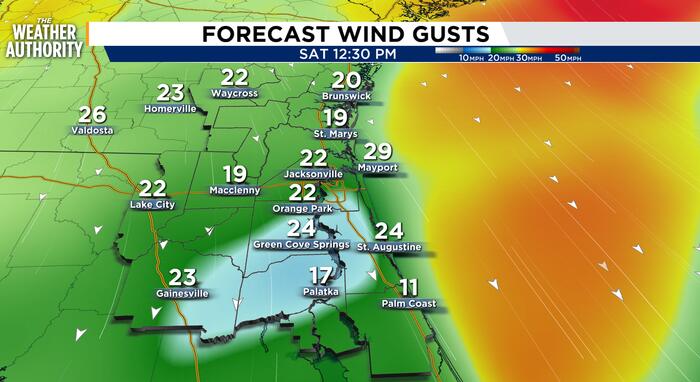
Sustained onshore winds are expected to reach 20 to 25 miles per hour along the coast, with gusts pushing near 30 to 40 miles per hour through the weekend.
Temperatures are forecast to fall by roughly 8 to 10 degrees compared to the warm stretch earlier this week, giving Jacksonville a true taste of winter by Sunday.
The National Weather Service has flagged a high risk of rip currents for Northeast Florida beaches, a threat that is expected to linger through early next week as the nor'easter winds persist.
Additional beach erosion is also a growing concern, given the already-weakened state of local shorelines from a previous round of northerly winds.
The coastlines of Duval, St. Johns, and Flagler counties face the highest flooding potential, particularly during high tide cycles through Tuesday.
The St. Johns River Basin is also being monitored for minor to moderate tidal flooding as onshore flow pushes water levels higher than normal throughout the early part of next week.
Isolated to scattered showers — and a few embedded storms — are possible Saturday through Tuesday, with the greatest rainfall totals expected near and along the beaches of Northeast Florida. Residents in low-lying and flood-prone areas along the coast are encouraged to stay alert as this system develops. |
25 Comments
Join the conversation
A real taste of winter by Sunday sounds pretty good to me honestly. Bring it on.
The inland fog thing always catches people off guard because everyone assumes it's a coast problem. It really isn't. Heads up out there.
Hoping the county sends out some alerts before that tidal flooding hits. Last time they were way behind and roads were already underwater.
Scattered storms Saturday through Tuesday and a noreaster on top of it. Stocking up on groceries tonight just to be safe.
That fog on 295 near the river is always the worst. Zero visibility and people still flying 70 mph. Slow down folks.
The beaches are already looking rough from that last round of northerly winds. More erosion on top of that is going to be bad.
Rip currents through early next week is rough. Lifeguard season is over at most beaches so people are on their own out there.
I really hope the boat ramps along the river get some extra attention this weekend. Tidal flooding makes those areas dangerous.
Been here my whole life and noreasers always catch people off guard. They drag on for days and the wind is relentless.
Honestly glad the warm stretch is sticking around through Friday at least. Enjoy it while it lasts people.
Woke up this morning and could not see across the street. Took my dog out and came right back in. Wild how fast that fog settled.
Minor to moderate tidal flooding along the coast through Tuesday is not a fun way to start the week. Keeping an eye on this for sure.
People really need to stop walking on the dunes too. Erosion is already bad and foot traffic makes it worse every single time.
Flagler county always seems to take the worst of these noreasers. Hope the county is paying attention to that flood potential.
80 degrees Thursday and then dropping 10 degrees by Sunday. My sinuses are already done with this week.
I drive out to the beaches before sunrise for work and that quarter mile visibility warning is real. Slow down out there everyone.
The St Johns River flooding is the part that worries me most. That basin backs up fast when the wind pushes water inland.
Ugh, was planning a beach day Saturday with the kids. Looks like that's off the table.
Those 20 to 40 mph gusts are going to make a mess of Amelia Island. Happened last November and the erosion was bad.
Already sandbagging the garage. We flooded twice last year during high tide events near Vilano Beach and I'm not going through that again.
Just moved here from up north and people told me Florida doesn't have real winters. This weekend might prove them wrong lol.
My backyard in Middleburg gets so foggy overnight you can't see the treeline. Was wondering when they'd put out an advisory.
80s in late fall and now a noreaster by the weekend. Florida weather never makes sense.
Every year people ignore the rip current warnings and every year we hear bad news. Please stay out of the water this weekend.
That fog on 9A this morning was no joke. Could barely see the car in front of me.