Jacksonville Weather Today: Strong Coastal Wind Gusts Expected |
A northeast Florida wind advisory and dangerous coastal wind gusts impacting the shoreline and waterways |
Jacksonville is bracing for a punishing stretch of wind-driven coastal hazards today, as a stalled cold front funnels relentless north-to-northeast winds across the region and slams the shoreline with dangerous force.
If you're checking Jacksonville weather today, the headline is straightforward: stay off the beach and keep boats docked.
A northeast Florida wind advisory is currently in place for coastal Duval County, running through the early morning hours of Monday, with forecasters warning that conditions will remain unsettled well into the start of the new week.
Coastal wind gusts are the defining danger of this weather event.
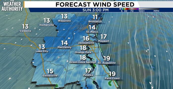
North-to-northeast winds are sustaining between 15 and 25 mph across the metro area, but along the beachside communities and the St. Johns River corridor, gusts are surging to between 30 and 45 mph — powerful enough to upend outdoor furniture, snap tree limbs, and create treacherous conditions on open water.
A gale warning is in effect over Atlantic coastal waters through Monday, a designation that signals genuinely dangerous marine conditions for recreational and commercial boaters alike.
Temperatures today will top out in the lower 70s across most of Northeast Florida, with skies ranging from partly to mostly cloudy throughout the day.
A slight chance of afternoon and evening showers exists, primarily for residents in St. Johns and Flagler counties.
Tonight brings little relief, with lows settling into the mid-50s to lower 60s and winds remaining gusty well past sunset.
The most serious concern along the coast is not the wind alone — it is what that wind is doing to the water.
Breaking surf is building to dangerous heights, with a high risk of rip currents confirmed along Jacksonville Beach and neighboring Atlantic shore communities through at least Monday morning.
Rip currents are the leading weather-related killer on Florida beaches, and conditions this weekend are being treated with the same gravity as a serious coastal storm event.
Beach erosion is also a concern, particularly during high tide cycles when surge-driven water pushes further up the shoreline than usual.
Minor tidal flooding is possible along the Intracoastal Waterway, the Atlantic coast, and through sections of the St. Johns River basin — a reminder that coastal wind events carry consequences far inland for Jacksonville-area neighborhoods.
Officials are urging residents to stay out of rough surf, heed posted beach flag warnings, and verify current marine conditions before heading onto the water in any vessel.
This is not a day to test the ocean. |
25 Comments
Join the conversation
Outdoor furniture already on its way down my street. Called it.
The color of the ocean on days like this is actually beautiful even if you cannot go in. Dark green and wild looking.
I wonder if the Jacksonville Beach pier took any damage overnight. Anyone been by there this morning?
Beach erosion is already bad at some spots near Neptune Beach. This weekend is not going to help at all.
No fishing today I guess. Those inlet conditions get sketchy real fast with northeast winds stacking up the swells.
Gale warnings on the Atlantic coastal waters are serious business. People treat them like suggestions and they are not.
My kids are so disappointed about the beach today. We drove down from Gainesville just for this weekend.
Stalled cold front means this could hang around for days. Seen it plenty of times. Stock up and stay home.
Rip currents are the scariest thing about Florida beaches and most people treat them like they are nothing
I live right off the beach and the wind last night was rattling my windows something fierce. Glad I moved my car away from the big oak out front.
Mid 50s tonight is actually going to feel cold after a week of warm weather. Grab a jacket.
Good call keeping boats docked. Saw the chop out near the inlet earlier and it was already pretty ugly before the gusts picked up.
The St. Johns corridor floods so fast when the wind pushes water back upstream. People new to the area have no idea.
Flagler getting showers on top of all this wind sounds like a rough Sunday for sure
I wonder how long this front is going to stay stalled. These wind events always seem to drag on longer than expected around here.
45 mph gusts on the beach are no joke. Even experienced surfers need to sit this one out.
Intracoastal flooding always creeps up on the neighborhoods around Palm Valley. Hoping it stays minor this time.
I keep telling my neighbors to bolt down their patio furniture and they never listen. Guaranteed someone loses a chair today.
The rip currents around here are seriously underestimated by tourists. Glad they are calling it out clearly.
Lower 70s with a breeze actually sounds kind of nice if you stay off the water lol
People still had their kids out near the water this morning near Atlantic Beach. The flags were up and everything.
Glad they put the gale warning out early. Lost a boat motor once ignoring one of those. Never again.
I wonder how bad the erosion is going to be at Huguenot this time
That St. Johns River flooding is no joke. My dock was underwater last time we had winds like this.
Went down to Jax Beach this morning anyway and wow the waves were massive. Turned right back around.